Lake Lila Trip Planning Stage
Trip Overview
Duration: 4 days, 3 nights
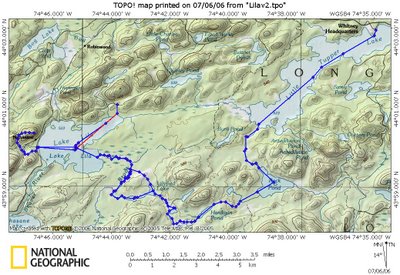
Distance: 16.11 Miles (13.03 H2O, 3.08 LAND)
Start: Little Tupper Lake
End: Lake Lila
Target Date: September 21 (thur) to 24 (sun)
Located in the William C. Whitney Wilderness Area, these lakes make up the largest motorless lake area in the Adirondacks. Camping on the lake is first come, first serve. From Lake Lila, hike up Fredrica Mountain for a great view of the lake and surrounding area.

This is a secluded section of the park that does not get a lot of traffic. Chances are we will be the only ones on this trail. I check with a local outfitter and only one group has gone through since the beginning of the season till now (July 7th, 2006). The entry and exit points for the portages (land crossing where you carry the canoe) may be muddy. The trails a marked but not regularly maintained. The trails transverse through woods and clearings in remote locations not accessible by outside trails. Speed on the water averages 3.5 miles an hour to enjoy the surroundings (although you can always paddle faster). Portage speeds vary based on weight, incline and distance with a minimum of 0.5 miles an hour for a 1 mile steep overloaded expedition (I’ve been there, and it not the way to do it). We will be traveling very light through the portage sections. I will discuss Tandem versus Solo crossings. While we could make it from Tupper Lake to Lila Lake in one day, I believe we should split it into 2 days and enjoy the scenery. This will break down the day into about 3 hours of travel per day. The rest of the day can be used to explore relax, collect firewood, set up camp and swim.
================================
Day 1:
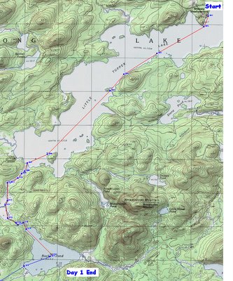
Start at the Little Tupper Lake Headquarters.
Total distance for the day is 6.77 miles. This is almost all paddling except for a minor carry if the water lever is low in the Rock Pound Outlet.
The final destination Rock Pond has 5 campsites on the edge of the pond and 1 on an island in the middle of the pond. We cane scope out the best location on this reltivly small pond witch is 1 mile N-S by 1 Mile E-W.
Day 2
The Point of this day is to travel light. Not nessasaraly fast, just light. Total distance traveled 4 miles, but 1.75 of them was a carry.
Compared to the Raquette River falls carry, these are all very mild. The idea is not to work to hard, just enjoy the view.
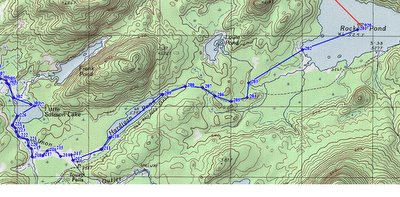
Segment 1: paddle 0.5 miles to the shore.
Segment 2: Carry cannoe and gear 1.5 mile to Hardigan Pond. This is the most physical aspect of the whole trip. Get this over with and it's all down hill. Anyone in desent shape can manage this portage. If you are doing cardio 3-4 times a week this will be the same as a 45 minute work out.
here id the profile of the carry:
 The total elevation difference is 50 feet and its mostly a gradule incline. Compared to Raquette which was 150 feet of steep climb. Appling lessoned learned from the Raquette Trip demands 2 people carrying one canoe.
Segment 3: Paddle Hardigan Pond for 0.6 miles.
Segment 4: Carry Cannoe 0.25 miles to Little Salmon Lake.
Segment 5: Paddle down stream to Little Salmon Lake for 1 mile.
Done for the day. Total distance traveled 4 miles, but 1.75 of them was a carry.

This location is in the middle of no-where, enyoy the view and make a fire.
Day 3:
Todays Goal: Get out of this place and make it to lake Lila 3.4 Miles away.
 Segment 1: Paddle 0.17 mile to shore
Segment 2: Carry 0.5 miles to Lilypad Pond.
Segment 3: Paddle 0.31 miles across Lilypad Pond.
Segment 4: Carry 0.88 miles to Shingle Shanty Brook.
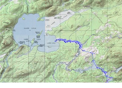
Segment 5: Paddle 2.0 miles down the brook to Lake Lila
Segment 6: Paddle 1.75 miles to the trail head.
Segment 7: Walk up to car and get food and drink from ice cold coolers.
Segment 8: carry back supplies to cannoe and find a campsite for the night.
Final destination. There are more than a dozen campsites on this lake and 4 of them are private -site on islands. there is even a shelter on the west side of the lake.
Duration: 4 days, 3 nights
Distance: 16.11 Miles (13.03 H2O, 3.08 LAND)
Start: Little Tupper Lake
End: Lake Lila
Target Date: September 21 (thur) to 24 (sun)
Located in the William C. Whitney Wilderness Area, these lakes make up the largest motorless lake area in the Adirondacks. Camping on the lake is first come, first serve. From Lake Lila, hike up Fredrica Mountain for a great view of the lake and surrounding area.

This is a secluded section of the park that does not get a lot of traffic. Chances are we will be the only ones on this trail. I check with a local outfitter and only one group has gone through since the beginning of the season till now (July 7th, 2006). The entry and exit points for the portages (land crossing where you carry the canoe) may be muddy. The trails a marked but not regularly maintained. The trails transverse through woods and clearings in remote locations not accessible by outside trails. Speed on the water averages 3.5 miles an hour to enjoy the surroundings (although you can always paddle faster). Portage speeds vary based on weight, incline and distance with a minimum of 0.5 miles an hour for a 1 mile steep overloaded expedition (I’ve been there, and it not the way to do it). We will be traveling very light through the portage sections. I will discuss Tandem versus Solo crossings. While we could make it from Tupper Lake to Lila Lake in one day, I believe we should split it into 2 days and enjoy the scenery. This will break down the day into about 3 hours of travel per day. The rest of the day can be used to explore relax, collect firewood, set up camp and swim.
================================
Day 1:
Start at the Little Tupper Lake Headquarters.
Total distance for the day is 6.77 miles. This is almost all paddling except for a minor carry if the water lever is low in the Rock Pound Outlet.

The final destination Rock Pond has 5 campsites on the edge of the pond and 1 on an island in the middle of the pond. We cane scope out the best location on this reltivly small pond witch is 1 mile N-S by 1 Mile E-W.
Day 2
The Point of this day is to travel light. Not nessasaraly fast, just light. Total distance traveled 4 miles, but 1.75 of them was a carry.
Compared to the Raquette River falls carry, these are all very mild. The idea is not to work to hard, just enjoy the view.
Segment 1: paddle 0.5 miles to the shore.
Segment 2: Carry cannoe and gear 1.5 mile to Hardigan Pond. This is the most physical aspect of the whole trip. Get this over with and it's all down hill. Anyone in desent shape can manage this portage. If you are doing cardio 3-4 times a week this will be the same as a 45 minute work out.
here id the profile of the carry:
 The total elevation difference is 50 feet and its mostly a gradule incline. Compared to Raquette which was 150 feet of steep climb. Appling lessoned learned from the Raquette Trip demands 2 people carrying one canoe.
Segment 3: Paddle Hardigan Pond for 0.6 miles.
Segment 4: Carry Cannoe 0.25 miles to Little Salmon Lake.
Segment 5: Paddle down stream to Little Salmon Lake for 1 mile.
Done for the day. Total distance traveled 4 miles, but 1.75 of them was a carry.

This location is in the middle of no-where, enyoy the view and make a fire.
Day 3:
Todays Goal: Get out of this place and make it to lake Lila 3.4 Miles away.
 Segment 1: Paddle 0.17 mile to shore
Segment 2: Carry 0.5 miles to Lilypad Pond.
Segment 3: Paddle 0.31 miles across Lilypad Pond.
Segment 4: Carry 0.88 miles to Shingle Shanty Brook.
Segment 5: Paddle 2.0 miles down the brook to Lake Lila
Segment 6: Paddle 1.75 miles to the trail head.
Segment 7: Walk up to car and get food and drink from ice cold coolers.
Segment 8: carry back supplies to cannoe and find a campsite for the night.
Final destination. There are more than a dozen campsites on this lake and 4 of them are private -site on islands. there is even a shelter on the west side of the lake.

0 Comments:
Post a Comment
<< Home